Mystery leaves faint clues, yet patterns speak when you read them right. In a landmark leap, Artificial intelligence helps experts expose shapes that time tried to erase. The breakthrough pairs speed with care, so evidence stays solid while horizons widen. Readers see how machines scan, humans confirm, and knowledge expands. The path ahead feels urgent, because fragile traces fade fast, and meanings depend on what we preserve now.
From Desert Traces to a Verified Breakthrough
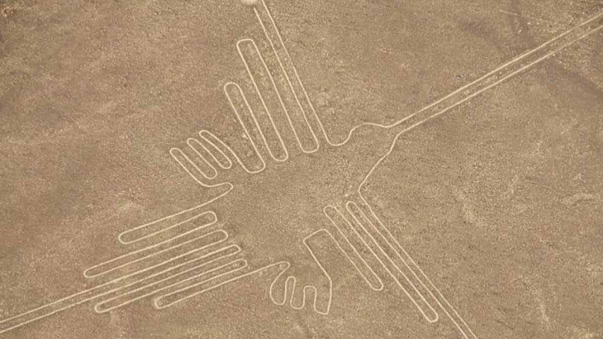
In only six months, a joint team from Yamagata University’s Institute of Nazca and IBM doubled the known geoglyphs in a UNESCO desert plain. They identified 303 previously unrecorded designs and published the advance in PNAS, with lead archaeologist Prof. Masato Sakai confirming the results.
The figures date between 200 BC and 650 AD, a span that covers complex ritual life and sophisticated engineering. Scale matters here, since some images stretch hundreds of meters across, yet lines stay crisp.
That precision reflects knowledge of geometry, spatial planning, and a culture skilled at designing for vast open ground. The find is not guesswork. Researchers flagged candidates digitally, then verified each site in the field. This rhythm—scan, check, document—makes the leap credible, because Artificial intelligence accelerates search while fieldwork secures context.
How Artificial intelligence Saw What Eyes Missed
For a century, scholars mapped this landscape with aerial photography, ground surveys, and hand-drawn plans. The new method trained algorithms on thousands of aerial images, so pattern recognition could detect faint, weathered strokes that human observers often overlook.
The system sifted terabytes of high-resolution satellite and drone imagery, then suggested likely shapes for review. According to Prof. Sakai, speed came from the model’s ability to screen data at scale, while careful auditing kept standards high.
Once flagged, archaeologists visited each site, recorded location and features, and ruled out noise from natural scars or modern tracks. The workflow pairs computer vision with field notebooks, GPS, and measured drawings. The result is a defensible map that grows faster than traditional sweeps, yet resists error. Because the terrain is huge, this blended approach closes gaps that would take lifetimes to cover on foot.
What the New Figures Reveal About Purpose
The newly recorded designs include felines, birds, fish, plants, and abstract forms. Their clean symmetry, despite size, proves disciplined planning, not random scraping.
Scholars now weigh functions with fresh data, because distributions and orientations matter. The working view favors ritual use: pathways for processions that linked people, landscape, and gods.
This aligns with Maria Reiche’s earlier notes on geometric rigor, while broadening the frame to movement and experience. Orientation, scale, and placement cluster along routes that make sense for ceremony, but they also fit roles in marking territory or timing seasonal cycles.
With each site added, patterns of spacing and sequence sharpen. That clarity helps test long-standing ideas without hype. It also deepens respect for craft. Exact lines across rough ground require rehearsed teams, planning grids, and reliable reference points. Here, Artificial intelligence supplies coverage, while human interpretation anchors meaning in lived practice.
Where Artificial intelligence Is Rewriting Fieldwork Elsewhere
The momentum reaches beyond one desert. In Europe, models now flag likely burial mounds across farmland and moor, even when erosion softens their profiles. Under dense forests, remote sensing and machine learning trace ancient settlements that once hid beneath canopy and leaf litter. At sea, algorithms scan bathymetry and sonar for shipwreck forms on the ocean floor.
In the United Arab Emirates, at Saruq Al Hadid, satellite data and AI revealed distribution patterns in artifacts, so teams could prioritize trenches with higher odds of insight. Dr. João Fonte of ERA Arqueologia calls this shift a leap in efficiency, because surveys that took years now finish in days.
When paired with photogrammetry and other remote-sensing layers, models turn raw pixels into working maps. Crews then mobilize with focus, cut waste, and protect fragile contexts. Speed, however, does not replace care; it gives experts better choices sooner.
Limits, Safeguards, and the Urgency of Protection
Archaeologists stress limits, because tools can overpromise. Dr. Alexandra Karamitrou of the University of Southampton, who builds AI for research, warns that models still misread scars, roads, or modern lines. False positives remain, so every candidate needs ground truth.
That is why teams keep auditing, measuring, and writing notes on site before anything enters the record. Even so, progress feels decisive. Algorithms keep improving with richer training sets, better labels, and clearer feedback loops.
As detection gets sharper, endangered places can be documented before they vanish to weather, construction, or looting. The Nazca designs, drawn between 200 BC and 650 AD, gain security as the map expands. Each precise curve adds context to belief, ritual, and artistry across one of the world’s most enigmatic cultural landscapes. Here, Artificial intelligence does not replace judgment; it scales attention so knowledge survives.
A Partnership That Changes How We Read Ancient Landscapes Today
This story shows disciplined teamwork, not magic. Models sweep wide. Specialists verify close. Together they protect meaning embedded in lines, spaces, and routes. PNAS publication, field checks, and clear attributions keep standards firm, while rapid screening opens responsible paths for new research. The prize is time. Fragile traces fade each season, yet coverage now grows faster than loss. With care and speed in balance, Artificial intelligence helps archaeology ask better questions—and answer them before silence wins.