A colossal presence sliced through the Atlantic, and science paid attention. The record belongs to a single shark, yet the impact stretches far beyond a headline. Researchers now hold new clues about movement, maturity, and reproduction in a top ocean predator. With precise tagging and careful handling, they gathered data that can change how we protect marine life. Curiosity meets method here, and the result is a turning point for conservation, technology, and public awareness.
Why this record matters for science and conservation
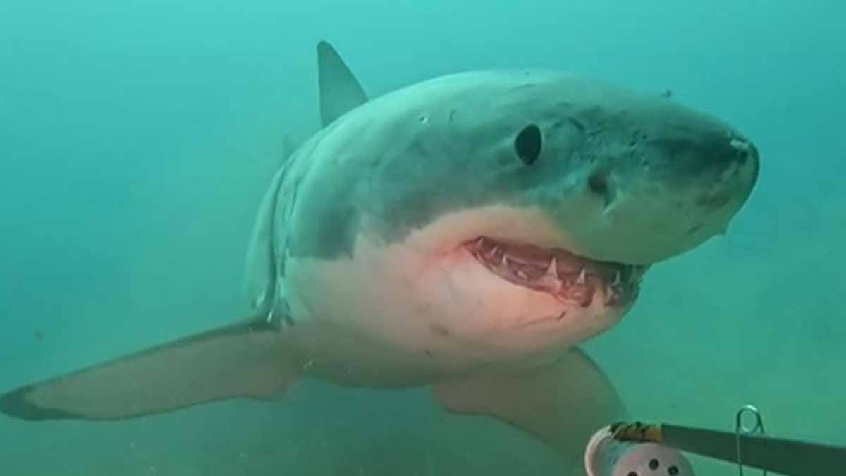
At 13 feet 9 inches and 1,653 pounds, the great white called Contender sets a clear size benchmark. The male was located roughly 45 miles off Florida’s east coast and tagged on January 17, 2025. One shark does not tell every story, yet a specimen this large opens new paths to understand breeding populations in the Western North Atlantic.
Dr. Harley Newton, OCEARCH’s chief veterinarian, notes males mature at about 11.5 feet and around 26 years. Contender measures about 14 feet, which places him in his early thirties and at the start of his reproductive life. That timing matters, because tracking a mature animal helps map where mating and pupping might happen across seasons.
Tagging a large male also sharpens risk analysis for coastal communities and fisheries. Scientists can link movements with water temperatures, prey availability, and shipping lanes. With time, they can distinguish normal seasonal routes from unusual shifts that may reflect climate patterns, local prey changes, or human pressure on habitats.
How researchers safely tagged the shark at sea
The OCEARCH team used monitored, baited break-away drumlines to keep control and reduce stress. When the fish took the bait, they brought him alongside the vessel with close biomedical oversight. This step-by-step approach enabled samples and measurements while protecting the animal’s health during a short handling window.
Two satellite devices went on board Contender: a SPOT tag on the dorsal fin and a PSAT archival tag. SPOT provides GPS locations when the dorsal fin breaks the surface, which happens every few days. PSAT records depth, light, and temperature, then releases after six months and transmits stored data.
The strategy blends fast pings at the surface with a long look underwater. SPOT shows the route; PSAT shows how deep, how warm, and how often. Together, they yield behavior patterns rather than isolated dots. Researchers then compare those patterns with prey maps, currents, and fronts, building an ecological picture that improves with every new track.
What the tracking reveals about movement, age, and breeding
Shortly after tagging, Contender moved about 292 miles toward northern Florida. Tracking data placed him near St. Augustine last Friday, which fits the long coastal ranges reported for white sharks. The route reinforces how wide these apex predators roam as they balance feeding, energy costs, and seasonal cues.
Age and size add context to that path. With maturity crossed and reproduction beginning, movements may hint at aggregation areas that matter for future pups. Samples from the urogenital system, collected during tagging, give laboratories evidence on health and reproductive status. That lab work complements tracks with biological facts.
Name matters for outreach too: Contender honors OCEARCH partner Contender Boats. The label helps the public remember the fish and follow progress. Outreach encourages citizen use of the free desktop tracker and mobile apps. People learn from real maps, and learning builds support for protecting habitats that sustain large marine predators.
What Contender means for Atlantic shark conservation strategies
OCEARCH has tagged and released 95 white sharks within its Western North Atlantic project. Each track joins a growing dataset that supports better decisions. Managers can see probable feeding zones, likely transit corridors, and seasonal hotspots. With evidence, protection tools become more targeted and more practical.
The PSAT will detach after six months, then report depth profiles and temperature ranges. Those records will refine models that predict where large fish go under varying conditions. When models align with SPOT routes, confidence grows. With stronger predictions, planners can reduce conflict with fisheries and reduce bycatch risk.
Data also turn interest into action. A striking animal attracts eyes, and eyes bring attention to policy. As people follow a route line, they also notice patterns in weather, currents, and prey. That awareness helps when new measures are proposed, because facts travel faster when the audience already cares.
Next steps, open questions, and how the public can follow
Anyone can watch Contender’s surface pings via OCEARCH’s free tracker and smartphone apps. Seeing a live map brings scale into focus and invites questions. Why pause here? Why sprint there? With more tracks, answers gain weight, and common myths fade in the face of steady, transparent data.
Rare wildlife sometimes appears in unexpected places, so the system flags unusual routes. Researchers then test if the signal reflects a genuine shift or a short-term quirk. Patterns matter over months, not minutes, so patience blends with curiosity. In time, confirmed detours can reveal new feeding grounds or brief thermal refuges.
This story ties into wider ocean science. The Atlantic is changing as heat, currents, and prey fields evolve. A single record fish does not write the whole script, yet it highlights what careful work can show. With consistent sampling, we learn where protection helps most and where pressure hits hardest.
A single giant hints at oceans still full of secrets
Contender’s journey brings ancient power into modern view, and the data keep rolling in. A vast map grows while a single shark moves, dives, and surfaces on its own terms. The lesson is simple and urgent: when we pair rigorous methods with open tools, we give oceans a real chance to recover.