Small marks in ancient mud flip a familiar story, because they point to people on this land far earlier than most of us learned. At White Sands, New Mexico, prints locked in lake beds now carry a firm date range. New radiocarbon tests match earlier results and tighten the case. The science is simple, the checks are strong, and the stakes are huge for human arrival on this continent.
Radiocarbon checks that support human arrival
New evidence comes from the same dunes that first drew notice. The team returned to White Sands and sampled mud tied to the track layers. An independent lab ran the numbers. Dates between 20,700 and 22,400 years align with the first study, which had dated seeds and pollen near the prints.
Skeptics worried that plant material might distort the clock, yet the new mud ages match the seed and pollen ages. Three different materials, tested by three labs, point in the same direction. That level of agreement is hard to dismiss, as Vance Holliday notes. The site also sits far south of the great ice sheets, which fits the timing.
Because the Last Glacial Maximum peaked around 23,000 years ago, the match matters. These footprints sit inside that window. The record is steady, the methods are standard, and the layers are clear. So this footing anchors human arrival during the coldest stretch of the last Ice Age.
From the Clovis story to a wider starting point
For decades, the neat tale began with the Clovis culture. People, we were told, crossed a land bridge from Siberia about 13,000 years ago. They spread south and left famous spear points near Clovis, New Mexico. That timeline shaped textbooks, exhibits, and fieldwork plans for years.
But the prints rewrite the first chapter, not the rest of the book. If people walked here more than 20,000 years ago, then the door opens to other routes and seasons. Movement may have hugged coasts or used short interior corridors as ice shifted. Life would have looked spare, fast, and clever.
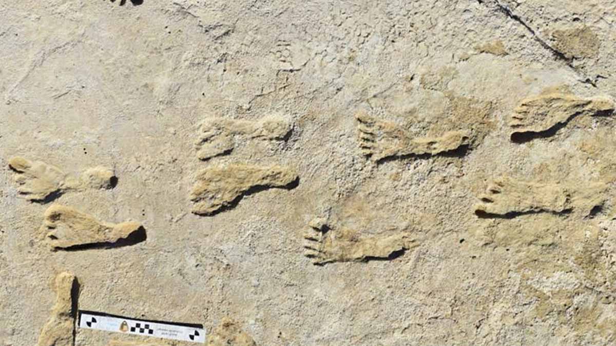
Trackways at White Sands capture quick passes across wet ground. Short paths suggest moments, not long camps. That helps explain missing toolkits or hearths. Mobile groups kept their gear, because raw stone was precious and far away. So we should not expect a debris field to prove human arrival beyond the prints themselves.
Where the landscape hid and kept human arrival
White Sands was once a chain of lakes. As waters fell, wind carved bright gypsum into vast dunes. The prints rest in an old stream bed that fed one of those lakes, then fell silent under shifting sand. Wind later scraped some layers away, while giant drifts buried the rest.
The basin’s map frames the story. The northern Tularosa Basin holds the Gypsum Sand Dunes and the Alkali Flat deflation basin. Modern Lake Lucero sits nearby, and the Lost River vanishes under dunes down-basin. A 1,204-meter contour outlines paleolake Otero’s reach. Field teams worked at Gypsum Overlook and along Alkali Flat’s west margin.
Crews cut fresh trenches in 2022 and 2023 to read the stack of lake beds. The layers show calm water times and storm times, then drying. Jason Windingstad joined the dig and described the strange shock of standing in tracks that reset lessons. That feeling grew stronger as the lab results reinforced the case for human arrival.
Methods, replication, and why artifacts remain scarce
Radiocarbon dating powered every step, and the checks run deep. Seeds, pollen, and now mud all point to the same Ice Age window. Labs working apart reached similar ranges, which boosts trust. Because materials and facilities differ, matching ages signal strong method control and clean samples.
The prints likely mark brief crossings, not long stays. People moved fast to hunt, scout, or fetch water. They would keep tools close, since new stone sources were not nearby. Littering blades or cores makes little sense for mobile bands. The logic favors light traces in mud, not heavy camps.
Absence of gear can tempt doubt, yet here the prints do the talking. Footfalls press through time in a way bones and hearth ash often do not. The sediments hold them, the dates frame them, and the ice history fits them. Taken together, the line of proof is tight.
What the new dates change about people and place
Timelines now stretch farther back than tidy classroom charts. Early people likely mixed routes, because weather and water shaped choices. Lakes offered reeds, birds, and paths on firm margins, while dunes rose and fell with wind. So movement looked seasonal, flexible, and bold.
Museums and syllabi will need updates, since the first page just moved. Models that start only with Clovis points miss an older phase of exploration. That older phase may leave fewer artifacts, yet prints can still trace it. Because each step fixes a moment, we can link those moments to climate swings.
Next steps are clear. Researchers will core more beds, test more layers, and sample more sites. As records grow, maps of early movement will sharpen. Arguments will continue, and they should, yet the White Sands results now set a high bar. Any rival claim must meet or beat this standard.
Why the footprints now reset our shared origin timeline
Evidence from White Sands narrows guesswork and raises better questions. Prints in layered mud, dated by separate labs and materials, point to people here during the cold maximum. This pushes human arrival deep into the Ice Age, while it reshapes routes, seasons, and risks. Debate will refine details, and new trenches will add lines, yet the core signal endures.