The ground stretches, the crust thins, and pressure from below finds a path upward. Deep flows inside Earth’s mantle surge in pulses that climb toward rifts, weaken rock, and let fresh lava spill out. This hidden motion, paced like a heartbeat, does not act alone; it answers to the pull of shifting plates and quietly sketches the outline of an ocean that does not yet exist.
How Earth’s mantle rises and feeds young rifts
Researchers sampled lava from more than 130 young volcanoes spread across a triple-junction rift zone. They compared rock chemistry with existing seismic and geologic maps and saw an upwelling that is not a tidy plume. Instead, it looks like a patchwork of hot channels and stacked blobs, each with its own signature. From Earth’s mantle, partially molten material ascends, guided by fractures overhead, and organizes itself along the stretches where plates open.
The team found that this system moves in pulses rather than as a steady fountain. Chemical striping inside the rocks marks those surges like beats on a monitor, which helps explain why lava eruptions can arrive in clustered episodes. As the plates above continue to pull apart, those pulses find less resistance, move faster, and concentrate where the crust is already weak. The crust then thins further, creating a feedback loop that favors repeated outpourings.
Because the lithosphere loses strength as it thins, rising heat can erode it from below and trim its thickness to extreme lows, in places near 15 kilometers. That change matters at the surface. It sets up zones where magma can stall, remix, and then break through in sheets that blanket the land. It also sets the stage for future seaways, since sustained thinning invites the ocean to enter once the land sags below sea level.
Pulses, plate motion, and what Earth’s mantle reveals
The rock chemistry shows that the plume’s behavior depends on the plates above: where extension is fast, flow narrows and speeds up; where extension is slow, it spreads out. That variation matches differences seen along neighboring rifts. In a fast-pulling arm, the path is tight and focused. In a slower arm, the plume flares laterally, feeds wider zones, and pushes heat over a broader area. The coupling is intimate, so surface strain patterns leave a fingerprint on the deep flow.
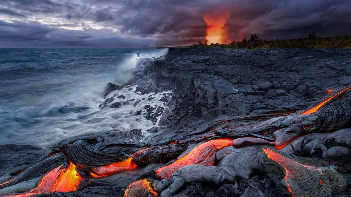
Scientists describe this coordination using a simple image: a heartbeat paced by a runner’s stride. The “beats” in the erupted lavas track pulses below, while the stride above—plate speed and plate thickness—sets the rhythm. Because the lithosphere can thin to roughly 15 kilometers, melts reach shallow reservoirs, and short volcanic bursts follow. Lava sheets bury older land, while swarms of small earthquakes signal fresh crust forming at depth and new faults opening.
As the process continues, seawater will one day flood into the lowest basins and begin to claim a corridor between two landmasses. The Horn will ultimately drift away from the mainland, as other continents once did when the Atlantic opened. In this view, Earth’s mantle does not simply feed volcanoes; it also sculpts coastlines on long timescales, writes the first lines of a marine map, and links deep chemistry to future geography that our grandchildren may recognize.
From deep chemistry to surface risks and timelines
The research also reframes how we read past events. Large igneous provinces—immense, short-lived flood-basalt episodes—have left signatures around the world. One such province produced the Giant’s Causeway about 60 million years ago, a reminder of how fast and vast these outpourings can be. When eruptions arrive in surges, gases matter. CO₂ and SO₂ can shift climate, acidify rain, and stress ecosystems quickly when volumes spike.
Because plume pulses can focus where plates are thinnest, identifying thin corridors becomes a practical priority. Maps that combine rift geometry with geochemical “barcodes” help point to likely vent alignments before they become obvious at the surface. That, in turn, can guide monitoring networks, early-warning priorities, and land-use choices near active fissures. With better constraints on pulse timing, agencies can plan for short eruption clusters rather than only for single events.
Future work extends this logic. Teams will map how fast hot material flows beneath thin plates and how the flow bends toward weak zones. They will test whether changes in plate speed alter pulse spacing, and whether crustal faults act like gates that open and close. They will also refine gas budgets to link eruptive tempo to climatic impact. In that broader picture, Earth’s mantle is not a background layer; it is an active partner in the surface story we live.
Why these subsurface pulses matter for tomorrow’s coasts
Seen together, the findings clarify a chain: deep pulses rise, plates steer, crust thins, and lava answers. Because pulses repeat, the surface records them as stripes in rock and bursts in activity. That rhythm explains past flood basalts, fits present swarms, and hints at a shoreline yet to form. As teams align geochemistry, seismic images, and rift mechanics, the case grows stronger that Earth’s mantle writes the prologue to a new ocean with each measured beat.