From the windows of the ISS, astronauts witness electric displays unlike anything seen from Earth’s surface. These dazzling bursts of light erupt silently above storms, transforming the upper atmosphere into a theater of colors and shapes. With NASA photos, the world now glimpses a side of lightning that had long remained hidden. Each image captures phenomena so rare and brief that they challenge what we know about storms.
A hidden theater above storms
High over thunderheads, in air as high as 55 miles, storms launch transient luminous events. Red sprites bloom like jellyfish for milliseconds, while blue jets spear toward the stratosphere. Violet halos and broad ultraviolet rings flare and fade. Each burst is fast, so ground cameras often miss it; however, NASA photos from orbit keep catching them, again and again, while sensors capture timing and brightness with precision.
Researchers now connect these flashes to real-world effects because they rattle charged layers in the upper atmosphere. ELVES—enormous ultraviolet rings—can expand for hundreds of miles. When they do, the ionosphere’s charge shifts, and long-range radio can flicker. Aircrews and operators need better warnings, since signals fail without notice during severe storms, and routes cross risky zones while the storm evolves, spreads, and strengthens.
Scientists care about chemistry too, since corona discharges shuffle nitrogen oxides between layers. That changes ozone and heat balance. Climate models need this vertical mixing, so they can predict warming with tighter bounds, while storm physics improves and satellite data fills old gaps.
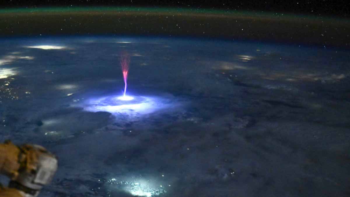
NASA photos and the watchful ASIM on the ISS
Since 2018, the European Space Agency’s ASIM has watched storms from an external ISS platform. High-speed cameras and photometers track flickers smaller than a fingernail and shorter than a heartbeat. The instrument times pulses, so analysts can see how cloud tops prime lightning. Those timings, together with brightness curves, show how energy races upward toward space and outward across charged layers during a fierce squall.
ASIM confirmed that crest-top discharges can inject power into the ionosphere and launch a vast ELVES ring. The ring forms in a blink, then spreads as a luminous circle. That sudden spread boosts charge and sometimes disturbs faraway radio paths. Ground arrays rarely spot the full ring because terrain and weather block views; the space view remains clear, steady, and wide during each orbit.
Ultra-brief corona bursts have joined the catalog. These spikes are so short that many instruments miss them. By aligning ASIM’s timestamps with lightning networks, scientists now separate overlapping events, filter noise, and test models. The work improves aviation guidance about cloud-top electric fields, so pilots and dispatchers can weigh distance, storm geometry, and altitude before choosing a route.
From sprites to blue jets: what the crew sees
Astronauts help, because the ISS cupola offers a stable window with seven panes. Through the Thor-Davis experiment, crew members mount a state-of-the-art camera behind glass. It records storms at up to 100,000 frames per second, so branching filaments appear in sharp, slow motion. These movies validate lab plasma tests, while they reveal patterns textbooks did not predict.
One study used synchronized views to fix the altitude of a single blue jet. That result showed the jet punched beyond familiar weather layers and into the stratosphere. The finding matters because jet paths mark strong fields that could signal broader storm changes, so controllers can adjust plans, shift loads, or delay departures when the risk grows.
Footage also feeds grid protection. Algorithms learn the shapes that precede destructive strikes, so utilities can brace lines, route power, and prevent cascading failures. In parallel, body-text references to NASA photos guide analysts to context: color, duration, and geometry. That context links each flash to a mechanism, so models improve and forecasts gain skill.
NASA photos meet high-energy pulses and tiny CubeSats
Some lightning sets off terrestrial gamma-ray flashes, which are energetic and fast. A brief pulse can match a chest X-ray for dose, so aircraft exposure matters. To map these invisible surges, Japan’s space agency and partners deployed Light-1 from the ISS. The shoebox-sized CubeSat carries detectors tuned to high-energy photons that skip past clouds and fog.
Light-1 records flashes over equatorial storm belts. Teams then align its timestamps with ground networks, so they can build a three-dimensional atlas. That atlas shows where and when gamma pulses recur, while it links pulses to storm stages, terrain, and sea-breeze boundaries. Because the method scales, a cluster of small satellites could watch the tropics with near-continuous coverage.
As data grows, planners can add thresholds to flight tools, while satellite operators set protective modes. Communications teams can harden links during risky windows. With NASA photos to anchor visible behavior, and gamma maps to tag invisible bursts, the picture tightens, and warnings become faster, clearer, and easier to trust.
Mapping invisible threats and the next wave of tools
At first glance, a sprite or ELVES ring looks like a curiosity. Yet these flashes stir the same layers that carry radio to submarines and across oceans. Disturb those layers and signals fade. Airlines need patterns that explain when routes cross danger, so they can shift altitudes or times while weather systems organize and stretch.
Engineers already plan faster detectors that trigger on multiple wavelengths. They want to span radio through hard X-ray with smarter onboard logic, so nothing slips by. As the ISS continues through this decade, ASIM and successors will expand the library. Each orbit adds fresh frames, while comparisons across seasons expose new rules that storms seem to follow.
Small satellites will multiply, feed real-time alerts, and guide weather centers. A fleet can watch distant oceans, since ground sensors are sparse there. Body text again references NASA photos to keep images tied to physics. That tie helps educators, forecasters, and operators explain risks in plain words, so decisions improve when minutes matter.
Guidance for readers who want the bigger picture
Storm science looks upward because the clues live above the rain. When cameras and detectors work together, models grow better, and daily tools get safer. With NASA photos as anchors, and precise timing from space and ground, scientists link color, altitude, and energy. The goal stays simple: understand the charged layers, protect people and systems, and keep essential signals clear.