A simple rule explains why some rivers travel as one thread while others braid into many. After a century of debate, new work shows how banks give way, channels widen, and paths divide. The evidence spans decades and continents, and it changes how we manage floods and plan restoration. The story begins in a lab tank, moves to satellites, then returns to living waterways with clear lessons.
What makes rivers split into many threads
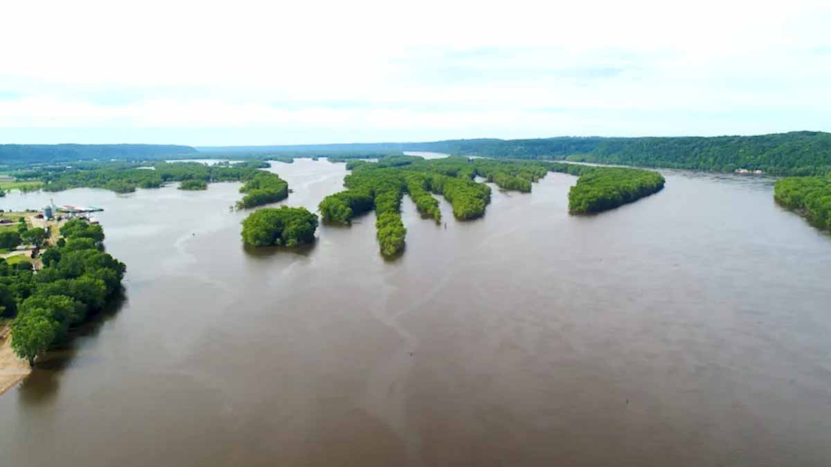
Geographers at UCSB analyzed 36 years of satellite images from 84 channels worldwide. Led by Austin Chadwick, the team found a consistent pattern. When banks erode faster than opposing banks can collect fresh sediment, a channel widens. With time, that widening produces new threads that crisscross, rejoin, and shift.
The insight first surfaced at the University of Minnesota’s St. Anthony Falls Laboratory. In scaled tanks, Chadwick kept measuring more bank loss than gain. It challenged classroom expectations. He dug into old Army Corps records, saw similar cases, and asked a hard question. Was the tank lying, or were field assumptions incomplete?
Testing in nature settled it. Single-threaded paths balance erosion with deposition, so the corridor stays tight and meanders. Braided systems tip the balance toward erosion, so the corridor grows. The amount of water does not rise on average. Instead, the same discharge moves through threads that persistently change in size. In short, rivers split because banks yield.
From lab tanks to global satellite proof
The team turned to Landsat archives through Google Earth Engine. They adapted particle image velocimetry, a lab tool, to track bank motion on space photos. This let them map where banks retreated and where material piled up along many landscapes.
Results were clear across diverse settings. Single-threaded paths showed near parity between material lost and gained. The corridor narrowed or held steady while classic bends migrated. By contrast, braided systems showed bank retreat outpacing bank buildup. The corridor widened again and again, until new threads formed bars, then islands.
Some famous waterways stood out for different reasons. The Mississippi River, long studied, remained single-threaded. Its corridor reflects intensive management, levees, and engineering. That stability makes it easier to observe the tight balance that keeps one main channel. The contrast helped verify the rule across very different controls.
How bank strength, bars, and flow sort rivers
What matters is not simply flow volume, but how forces move grains and reshape banks. In braided corridors, much sediment lands on the bed, not the sides. Bed deposition builds bars and low islands. These forms split and steer water into separate threads that wax and wane.
Senior author Vamsi Ganti notes that discharge still moves through the corridor without net gain. Yet thread sizes shuffle constantly, so the planform never rests. This dynamic explains why braided corridors confound fixed blue lines on maps. They live in motion, and their geometry remembers recent floods, not distant history.
Exceptions proved the rule useful. Brazil’s São Francisco did not match the pattern until context was added. Upstream dams and irrigation shrank the corridor and altered supply. Human actions had moved the system away from its baseline behavior. With that accounted for, the rule still guided judgment about rivers and their forms.
Exceptions, human fingerprints, and what they reveal
The twentieth century boxed many waterways behind levees and concrete. That opened land for cities and fields, but it severed floodplains. Cutoff floodplains sink relative to channels, while beds can rise. When a wall fails, water spreads into a basin that can no longer share the load.
Hurricane Katrina showed that risk clearly, as Chadwick’s team reminds. Once the levee broke, widespread flooding followed. The floodplain had been isolated for so long that it sat lower than the channel. Ponding grew, damage surged, and the flood told a plain story about lost space.
Old photos reveal how common multi-threaded forms once were. The Los Angeles corridor showed multiple threads in the 1930s, then concrete fixed a single path. Many urban channels that look simple now may have braided in the past. That memory matters because design choices should match former behavior.
Space, time, and rethinking restoration math
Planning must start with honest room. The study offers a formula to estimate corridor width and recovery time for a channel moving back toward its natural state. It considers how fast a corridor can abandon old paths and whether it tends to braid or stay single. Those estimates inform budgets and timelines.
One result has big impact: single-threaded channels need roughly ten times more space and time than braided ones, assuming equal stream power. That ratio changes feasibility. Projects written off as too large may be workable if a channel was misclassified. Correct labels save money and reduce false starts.
Next steps expand the lens. Ganti’s group tracks how planforms speed up or slow down over decades, seeking climate and development signals. Chadwick, now at Columbia’s Lamont-Doherty Earth Observatory, is probing why erosion dominates in some settings. Evan Greenberg uses NASA JPL imagery to see how dams reshape pathways. Their combined work will guide rivers work long after today’s plans.
Why this new rule reshapes planning and daily life by water
The lesson is elegant and practical. Bank erosion versus bank buildup decides whether a corridor stays single or splits. With that rule, managers can size restoration space, set timelines, and prepare for floods with fewer surprises. Use it where rivers meet cities, farms, and wetlands, and act early while options remain open.